柳 川 竜 一 RYOICHI YANAGAWA
|
 2015.06撮影  ハンコ絵 ハンコ絵 |
|
学位取得
職 歴Chuden CTI Co., Ltd.(解析アナリスト・エンジニアとして)2004.4-2012.4
岩手大学地域防災研究センター 自然災害解析部門(研究員として) 2012.05-2016.03
香川高等専門学校建設環境工学科 講師(研究者として) 2016.04-
所属学会
資格・免許
Research Gate |
||
論文一覧/List of Publication
査読有り
- 浅野敏之・右田健二・柳川竜一・山下隆男(1999.11):南九州沿岸および南西諸島海域における津波の広域数値計算,海岸工学論文集,第46巻,pp.326-330.
Toshiyuki Asano, Kenji Migita, Ryoichi Yanagawa, Takao Yamashita (1999.11): Calculations of Tsunami Propagation over a Large Ocean Area Stretching from Southern Kyushu to Nansei Islands, Journal of Coastal Engineering, JSCE, Vol.46, pp.326-330. - 矢持進・小田一紀・柳川竜一・山根和夫・田代孝行・新瀬幾恵(2001.11):大阪湾湾奥域の環境特性と大型底生動物群集の時系列変化,海岸工学論文集,第48巻,pp.1191-1195.
Susumu Yamochi, Kazuki Oda, Ryoichi Yanagawa, Kazuo Yamane, Takayuki Tashiro, Ikue Arase (2001.11): Environmental Characteristics and Temporal Changes of Demersal Fishes and Crustaceans in Inner Osaka Bay, Journal of Coastal Engineering, JSCE, Vol.48, pp.1191-1195. - Yamochi S., Yanagawa, R. and Oda, K.(2003):Nitrogen budget at two artificial tidal flats along the coastal area of Osaka Bay, Japan, WIT Transactions on Ecology and the Environment, Vol.65, Water pollution Ⅶ, pp.93-102.
- 柳川竜一・矢持進・中谷恵美・小田一紀(2002.11):大阪南港野鳥園湿地の環境特性と生物多様性を重視した浅場環境の造成条件,海岸工学論文集,第49巻,pp.1281-1285.
Ryoichi Yanagawa, Susumu Yamochi, Emi Nakaya, Kazuki Oda (2002.11): Environmental Characteristics and Conditions to Enhance the Biological Diversity in a Salt Marsh of Osaka Nanko Bird Sanctuary, Journal of Coastal Engineering, JSCE, Vol.49, pp.1281-1285. - 矢持 進・柳川竜一・松久純世(2003.04):高水温時の大阪南港野鳥園人工塩性湿地での窒素,浮遊懸濁物,クロロフィルa収支,水環境学会誌,26,pp.443-448.
Susumu YAMOCHI, Ryoichi YANAGAWA and Sumiyo MATSUHISA (2003.04): Nitrogen, Suspended Solids and Chlorophyll-a Budget of Artificial Salt Marsh in Osaka Nanko Bird Sanctuary at High-Water-Temperature Periods, Journal of Japan Society on Water Environment, Vol.26, No.7, pp.443-448. - Ryoichi Yanagawa, Susumu Yamochi, Sumiyo Matsuhisa(2003.05):Nitrogen budget of Artificial Salt Marsh in Inner Osaka Bay, Proceedings of The Thirteenth International Offshore and Polar Engineering Conference(ISOPE), pp.263-267.
- 矢持進・柳川竜一・橘実典(2003.11):大阪南港野鳥園湿地における物質収支と水質浄化機能の評価,海岸工学論文集,第50巻,pp.1241-1245.
Susumu Yamochi, Ryoichi Yanagawa and Minori Tachibana (2003.11): Budget of Nutrients and Evaluation of Water Purification Ability at the North Pond of Nanko Bird Sanctuary, Journal of Coastal Engineering, JSCE, Vol.50, pp.1241-1245. - 柳川竜一・矢持進・橘実典(2004.11):潟湖的地形を有した都市型塩性湿地造成における問題点と解決に向けた提案,海岸工学論文集, 第51巻,pp.1196-1200.
Ryoichi Yanagawa, Susumu Yamochi and Minori Tachibana (2004.11): Problems and Approach for their Solution of the Lagoon Type Salt Marsh Constructed in the Vicinity of Urban Area, Journal of Coastal Engineering, JSCE, Vol.51, pp.1196-1200. - 矢持進・柳川竜一・平井研・藤原俊介(2005.07):生態系の変動を考慮した順応的管理-物質収支からみて-,海洋開発論文集,21,pp.77-82.
Susumu YAMOCHI, Ryouichi YANAGAWA, Ken HIRAI and Shunsuke FUJIWARA (2005.07): ADAPTIVE MANAGEMENT IN RELATION TO THE SUCCESSION OF ECOSYSTEMS FROM THE VIEWPOINT OF MATERIAL BUDGET, Annual Journal of Civil Engineering in the Ocean, Vol.21, pp.77-82. - 柳川竜一(2005.03):大都市河口域に位置する人工塩性湿地生態系の生物生息・水質浄化・物質循環機能に関する研究,大阪市立大学博士論文
Ryoichi Yanagawa (2005.03): A Research on the Function of Habitats, Water Purification and Nutrient Cycling of the Salt Marsh in the Vicinity of the Urban Estuary - 長谷川一幸・清野通康・横田瑞郎・丸茂恵右・市川哲也・長谷川晃一・柳川竜一 (2009.03):現地観測と数値シミュレーション解析による大阪湾の湾奥部におけるDO分布特性の把握,海洋調査技術,21(1),p1-12.
Kazuyuki Hasegawa, Michiyasu Kiyono, Mizurou Yokota, Yasushi Akimoto, Keiyu Marumo, Tetsuya Ichikawa, Kouichi Hasegawa, Ryouichi Yanagawa (2009.03): Observations and Numerical Simulation Model Analysis Results of Dissolved Oxygen Characteristics in an Enclosed Coastal Sea, Osaka Bay, Journal of the Japan Society for Marine Surveys and Technology, 21(1) p.1-12. - 長谷川一幸・清野通康・横田瑞郎・市川哲也・長谷川晃一・柳川竜一 (2009.06):発電所取放水量の変化が放水口周辺の溶存酸素量分布に与える影響について,海洋開発論文集,25,pp.1281-1286.
Kazuyuki HASEGAWA, Michiyasu KIYONO, Mizurou YOKOTA, Tetsuya ICHIKAWA, Kouichi HASEGAWA and Ryouichi YANAGAWA (2009.06): INFLUENCE OF CHANGING IN THE DISCHARGE WATER VOLUME FROM POWER PLANT ON THE DISSOLVED OXYGEN CONCENTRATION NEAR THE POWER PLANT, Annual Journal of Civil Engineering in the Ocean, Vol.25, pp.1281-1286. - 岡辺拓巳・柳川竜一・青木伸一・加藤茂(2011.11):天竜川河口沖合海域の流れの時空間変動特性,土木学会論文集B2(海岸工学),Vol67,No.2,I_336-I_340.
Takumi OABE, Ryoichi YANAGAWA, Shin-ichi AOKI and Shigeru KATO (2011.11): Spatio-temporal Properties of Currents off the Tenryu River Mouth, J. JSCE, Ser. B2, Vol.68, No.2, I-336-I340. - 柳川竜一・中西敬・高瀬博文・中谷明泰・西田愛実(2013.06):栄養塩供給手法としての海底耕耘による海底土粒子分布の現地観測および拡散範囲推定,土木学会論文集B3(海洋開発), Vol. 69, No.2,p.I_527-I_532.
Ryoichi YANAGAWA, Takashi NAKANISHI, Hirofumi TAKASE, Akihiro NAKATANI and Aimi Nishida (2013.06): ON-SITE AND NUMERICAL MODEL STUDY TO ESTIMATE THE SEDIMENT PARTICLE BY CULTIVATION OF SEA BOTTOM AS THE NUTRIENT SUPPLY TECHNIQUE, Journal of Japan Society of Civil Engineers, Ser. B3, Vol. 69, No.2, I_527-I_532. - 小笠原敏紀・古坂梢・柳川竜一・岩間俊二・堺茂樹(2013.11):東北地方太平洋沖地震津波による岩手県沿岸における建物被害の特性,土木学会論文集B2(海岸工学),Vol69, No.2, I_356-I_360.
Toshinori OGASAWARA, Kozue KOSAKA, Ryoichi YANAGAWA, Syunji IWAMA and Shigeki SAKAI (2013.11): Characteristics of Buildings Damage due to Tohoku Earthquake and Tsunami in Iwate Prefecture, J. JSCE, Ser. B2, Vol.69, No.2, I_356-I_360. - Ryoichi Yanagawa, Shigeki Sakai(2014.06): Relational Analysis between Tsunami and House Damage at the Inundation Area in Iwate, Japan, The 34th International Conference on Coastal Engineering (ICCE2014), Oral Presentation E165, Coastal Engineering Proceedings.
- 柳川竜一・堺茂樹(2014.06):津波浸水深と建物密集度に着目した東日本大震災津波に関する建物被害特性,土木学会論文集B3(海洋開発), Vol. 70, No.2, I_438-I_443.
Ryoichi YANAGAWA and Shigeki SAKAI (2014.06): BUILDING DAMAGE CHARACTERISTICS OF THE GREAT EAST JAPAN EARTHQUAKE TSUNAMI FOCUSED ON THE INUNDATION HEIGHT AND BUILDING DENSITY, Journal of Japan Society of Civil Engineers, Ser. B3, Vol. 70, No.2, I_438-I_443. - 柳川竜一・堺茂樹(2014.09):岩手県沿岸地域を対象とした東日本大震災津波に関する地理・来襲津浪・被害建物特性,自然災害科学,Vol.33, No.2, pp.145-159.
Ryoichi Yanagawa and Shigeki Sakai (2014.09): Topographical, Propagating Tsunami and Suffering Building Features by the Great East Japan Earthquake Tsunami in the Iwate Coastal Region, Journal of Japan Society for Natural Disaster Science, Vol.33, No.2, pp.145-159. - 柳川竜一・虻川佑太・越野修三・堺茂樹・南正昭(2014.09):航空写真とDEMデータから推定した東日本大震災での津波遡上高の分布とそれら地理的特性,自然災害科学,Vol.33,特別号,pp.53-63.
Ryoichi Yanagawa, Yuta Abukawa, Shuzo Koshino, Shigeki Sakai and Masaaki Minami (2014.09): Estimation of Tsunami Run-up Height by the Great East Japan Earthquake Tsunami Determined from Aerial Photographs and DEM, and Their Geographical Characteristics, Journal of Japan Society for Natural Disaster Science, Vol.33, Special Issue, pp.53-63. - 柳川竜一・藤森直人・菅野航・堺茂樹(2014.11):東北地方太平洋沖地震に伴い地盤沈下した岩手県南部地域の冠水被害とその影響範囲推定,土木学会論文集B2(海岸工学),Vol.70,No.2,I_1336-I_1340.
Ryoichi YANAGAWA, Naoto FUJIMORI, Wataru KANNO and Shigeki SAKAI (2014.11) The Tidal Flooding Damage and Estimation of its Impact Area at the Iwate Coast Where the Ground Sank by the Great East Japan Earthquake, J. JSCE, Ser. B2, Vol.70, No.2, I_1336-I_1340. - Zati Sharip, Ryoichi Yanagawa, Tomohiko Terasawa (2015.04): Eco-Hydrodynamics Modeling of Chini Lake: Model Description, Journal of Environmental Modeling & Assessment, 10.1007/s10666-015-9464-4
- 柳川竜一・松林由里子・南正昭(2015.09):降雪期に着目した岩手県津波浸水区域における津波避難路の簡易的な危険性評価,自然災害科学,Vol.34,特別号,pp.1-10.
Ryoichi Yanagawa, Yuriko Matsubayashi and Masaaki Minami (2015.09): Simple Risk Assessment of the Tsunami Evacuation Route in View of Snow Season at the Tsunami Inundation Area in Iwate Prefecture, Journal of Japan Society for Natural Disaster Science, Vol.34, Special Issue, pp.1-10. - Ryoichi Yanagawa, Shuzo Koshino(2016.03): Tsunami Inundation Area and Run-up Height in the Iwate Coastal Region Following the Great East Japan Earthquake as Estimated from Aerial Photographs and Digital Elevation Data, Natural Hazards, DOI:10.1007/s11069-016-2285-1.
- Ryoichi Yanagawa(2016.07): The Development of Building Group Destruction Probability Model Based on the Experience of the Great East Japan Earthquake Tsunami, The 35th International Conference on Coastal Engineering (ICCE2016), Oral Presentation, Accepted.
査読無し
- 矢持進・重松孝昌・柳川竜一・山口仁士(2002.11):内湾浄化システムが有機物の循環に及ぼす影響の定量的評価に関する研究-長崎県形上湾における小型セディメントトラップを用いた事前検討-,第40回水産海洋学会研究発表大会,pp.67-68.
Susumu Yamochi, Takaaki Shigematsu, Ryoichi Yanagawa, Hitoshi Yamaguchi (2002.11): Study on Quantitative Assessment of Organic Material Circulation by the Inner Bay Purification System -Advance Inspection Using the Small-Scale Sediment Trap at the Katagami Bay, Nagasaki Prefecture-, The 40th Annual Scientific Meeting of Japanese Society of Fisheries Oceanography, pp.67-68. - 矢持進・柳川竜一・平井研(2006.05):都市近郊干潟域におけるアオサの大量発生が底質環境に及ぼす影響,日本船舶海洋工学会講演会論文集,2006K-OS5-2, pp.99-100.
Susumu Yamochi, Ryouichi Yanagawa, Ken Hirai (2006.05): The effect of dense blooms of Ulva species on the environment of bottom sediment at the tidal flat of urban coastal areas,The Japan Society of Naval Architects and Ocean Engineers,2006K-OS5-2, pp.99-100. - 石井光廣・片山知史・小畠大典・内藤大輔・柳川竜一(2012.11):東京湾におけるマコガレイの産卵場,水産海洋学会研究発表大会,pp.90.
Mitsuhiro Ishii, Tomofumi Katayama, Daisuke Kohata, Daisuke Naito, Ryoichi Yanagawa (2012.11): Investigation of Spawning Site of Pleuronectes Yokohamae by Using Numerical Model Technique, The Japanese Society of Fisheries Oceanography, pp.90. - 石川史織・松林由里子・柳川竜一・堺茂樹(2013.03):岩手県におけるさけ回帰率の変化と物理的環境,土木学会東北支部技術研究発表会,Ⅱ-8, 2p.
Shiori Ishikawa, Yuriko Matsubayashi, Ryoichi Yanagawa, Shigeki Sakai (2013.03): Time Series Variation of Salmon Homing Rate and Water Environment in Iwate, The Meeting of The Tohoku Branch of Japan Society of Civil Engineering, Ⅱ-8, 2p. - 山本裕子・古坂梢・小笠原敏記・柳川竜一・堺茂樹(2013.03):東北地方太平洋沖地震津波による岩手県沿岸地域の街区スケールの建物被害の特性,土木学会東北支部技術研究発表会,Ⅱ-49, 2p.
Yuko Yamamoto, Kozue Kosaka, Toshinori Ogasawara, Ryoichi Yanagawa, Shigeki Sakai (2013.03): The Building Damage Characteristics of the Urban Subdivision Scale Unit by the Great East Japan Earthquake Tsunami, The Meeting of The Tohoku Branch of Japan Society of Civil Engineering, Ⅱ-49, 2p. - 伊藤咲良・松林由里子・堺茂樹・柳川竜一(2013.03):岩手県沿岸における漁船の津波避難と情報取得手段,土木学会東北支部技術研究発表会,Ⅱ-78, 2p.
Sakura Ito, Yuriko Matsubayashi Shigeki Sakai, Ryoichi Yanagawa (2013.03): Tsunami Evacuation of Fishery Boat and Information Acquisition Method at the Iwate Coastal Area, The Meeting of The Tohoku Branch of Japan Society of Civil Engineering, Ⅱ-78, 2p. - 虻川佑太・松林由里子・柳川竜一・堺茂樹(2013.03):岩手県沿岸域に位置する小中学校の津波避難経路,土木学会東北支部技術研究発表会,Ⅱ-79, 2p.
Yuta Abukata, Yuriko Matsubayashi, Ryoichi Yanagawa, Shigeki Sakai (2013.03): The Tsunami Evacuation Route of Schools in Iwate Coastal Area, The Meeting of The Tohoku Branch of Japan Society of Civil Engineering, Ⅱ-79, 2p. - 石川史織・松林由里子・柳川竜一(2013.05):安家川におけるさけ回帰率の変化と水温の関係,日本水産工学会平成25年度日本水産工学会学術講演会,pp.185-186.
Shiori Ishikawa, Yuriko Matsubayashi, Ryoichi Yanagawa (2013.05): The Relationship Between the Water Temperature and the Salmon Homing Rate at River Akka, The Meeting of H25 Japanese Society of Fisheries Engineering, pp.185-186. - 遠藤徹・坪井研・柳川竜一・矢持進(2013.07):低次生態系モデルによる大阪湾への流入負荷の時・空間的分散化の環境改善評価,日本沿岸域学会平成25年度全国大会,セッション9-6, 4p.
Toru Endo, Kiwamu Tsuboi, Ryoichi Yanagawa, Susumu Yamochi (2013.07): Environmental Remediation Evaluation for the Temporal-Spatial Decentralization of the Organic Load to the Osaka Bay by Using the Ecosystem Model, The H25 Annual Meeting of Japanese Association for Coastal Zone Studies, Session9-6, 4p. - 柳川竜一・堺茂樹・小笠原敏記(2013.09):岩手県沿岸地域を対象とした東日本大震災津波に関する地理・来襲津波・被害建物特性ならびに地域特性,第32回日本自然災害学会学術講演会,pp.33-34.
Ryoichi Yanagawa, Shigeki Sakai, Toshinori Ogasawara (2013.09): Topographical, Propagating Tsunami and Suffering Building Features and localities at the Iwate Coastal Region, The 32th Annual Meeting of Japan Society for Natural Disaster, pp.33-34. - 柳川竜一・堺茂樹・越野修三(2013.11):東日本大震災の津波遡上境界線から得られた岩手県における津波遡上の地域特性,第22回地理情報システム学会学術研究発表大会, F-7-2, 4p.
Ryoichi YANAGAWA, Shigeki SAKAI, Shuzo KOSHINO (2013.11): Regional Characteristics of Tsunami Height in Iwate Derived from Tsunami Run-up Borderline of the Great East Japan Earthquake, The 22th Annual Meeting of GIS Association of Japan, F-7-2, 4p. - 柳川竜一・越野修三・南正昭(2015.10):東日本大震災時における釜石沿岸地域の災害初動対応特性と減災に向けたいくつかの考察について,第24回地理情報システム学会学術研究発表大会, E-5-3, 4p.
Ryoichi YANAGAWA, Shuzo KOSHINO, Masaaki MINAMI(2015.10): Regional Characteristics of Disaster Initial Responses Against the Great East Japan Earthquake at the Kamaishi Coastal Area and Some Discussions for the Disaster Mitigation, The 24th Annual Meeting of GIS Association of Japan,E-5-3, 4p. - 柳川竜一・松林由里子・南正昭(2016.03):津波避難を要する岩手県内小中学校の地域特性,平成27年度土木学会東北支部技術研究発表会,Ⅱ-90.
Ryoichi Yanagawa, Yuriko Matsubayashi, Shunji Iwama, Masaaki Minami(2016.03): Regional Characteristics of schools in Iwate coastal area where tsunami evacuation is considered necessary,Ⅱ-90.
年報・報告書
- 長谷川一幸・清野通康・横田瑞郎・秋本泰・丸茂恵右・市川哲也・長谷川晃一・柳川竜一(2011.05):発電所取放水が大阪湾湾奥部における溶存酸素の移動に与える影響について,海洋生物環境研究所研究報告書(海生研研報),第14号,p9-18.
Kazuyuki Hasegawa, Michiyasu Kiyono, Mizurou, Yokota, Yutaka Akimoto, Keiyu Marumo, Tetsuya Ichikawa, Kouichi Hasegawa and Ryouichi Yanagawa (2011.05): Influence of the Discharge Water from Power Plant on the Dissolved Oxygen Displacement in an Enclosed Coastal Sea, Osaka Bay, Rep. Mar. Ecol. Res. Inst., No.14, 9-18, 2011. - 平瑞樹・柳川竜一・福徳康雄・尾上昌平・赤木功(2013.03):東日本大震災の津波による低平地の被害と農地復旧対策の現況調査,「南九州から南西諸島における総合的防災研究の推進と地域防災体制の構築」報告書,鹿児島大学地域防災教育研究センター,pp.131-135.
- 公益社団法人土木学会東北支部(2013.08):東日本大震災に関する東北支部学術合同調査委員会報告書DVD,第2部門(河川工学、海岸工学)
- 岩手大学地域防災研究センター(2013.05):平成24年度地域防災研究センター年報,pp.20-21.
- 岩手大学地域防災研究センター(2014.05):平成25年度地域防災研究センター年報,pp.32-33.
- 岩手大学地域防災研究センター(2015.08):平成26年度地域防災研究センター年報,pp.42-43.
- 岩手大学地域防災研究センター(2015.08):平成27年度地域防災研究センター年報,作成中
学会発表(口頭発表,発表者には下線)
- 第46回海岸工学講演会(土木学会主催),浅野敏之・右田健二・柳川竜一・山下隆男:南九州沿岸および南西諸島海域における津波の広域数値計算,鳥取県米子市,1999年11月
- 第48回海岸工学講演会(土木学会主催),矢持進・小田一紀・柳川竜一・山根和夫・田代孝行・新瀬幾恵:大阪湾湾奥域の環境特性と大型底生動物群集の時系列変化,熊本県熊本市,2001年11月
- 第40回水産海洋学会研究発表大会(水産海洋学会主催),矢持進・重松孝昌・柳川竜一・山口仁士:内湾浄化システムが有機物の循環に及ぼす影響の定量的評価に関する研究-長崎県形上湾における小型セディメントトラップを用いた事前検討-,東京都内,2002年11月
- 第49回海岸工学講演会(土木学会主催),柳川竜一・矢持進・中谷恵美・小田一紀:大阪南港野鳥園湿地の環境特性と生物多様性を重視した浅場環境の造成条件,北海道釧路市,2002年11月
- The 13th International Offshore and Polar Engineering Conference (hosted by International Society of Offshore and Polar Engineers), Ryoichi Yanagawa, Susumu Yamochi, Sumiyo Matsuhisa: Nitrogen budget of Artificial Salt Marsh in Inner Osaka Bay, Honolulu U.S.A., May 2003
- 第50回海岸工学講演会(土木学会主催),矢持進・柳川竜一・橘実典:大阪南港野鳥園湿地における物質収支と水質浄化機能の評価,東京都内,2003年11月
- 第51回海岸工学講演会(土木学会主催),柳川竜一・矢持進・橘実典:潟湖的地形を有した都市型塩性湿地造成における問題点と解決に向けた提案,三重県志摩市,2004年11月
- 第30回海洋開発シンポジウム(土木学会主催),矢持進・柳川竜一・平井研・藤原俊介:生態系の変動を考慮した順応的管理-物質収支からみて-,北海道小樽市,2005年7月
- 平成18年関西支部春季講演会(日本船舶海洋工学会主催),矢持進・柳川竜一・平井研:都市近郊干潟域におけるアオサの大量発生が底質環境に及ぼす影響,大阪府吹田市,2006年5月
- 第34回海洋開発シンポジウム(土木学会主催),長谷川一幸・清野通康・横田瑞郎・市川哲也・長谷川晃一・柳川竜一:発電所取放水量の変化が放水口周辺の溶存酸素量分布に与える影響について,神奈川県横浜市,2009年6月
- 第58回海岸工学講演会(土木学会主催),岡辺拓巳・柳川竜一・青木伸一・加藤茂:天竜川河口沖合海域の流れの時空間変動,岩手県盛岡市,2011年11月
- 第50回水産海洋学会研究発表会(水産海洋学会主催),石井光廣・片山知史・小畠大典・内藤大輔・柳川竜一:東京湾におけるマコガレイの産卵場,東京都内,2012年11月
- 土木学会東北支部技術研究発表会(土木学会主催),石川史織・松林由里子・柳川竜一・堺茂樹:岩手県におけるさけ回帰率の変化と物理的環境,宮城県仙台市,2013年3月
- 土木学会東北支部技術研究発表会(土木学会主催),山本裕子・古坂梢・小笠原敏記・柳川竜一・堺茂樹:東北地方太平洋沖地震津波による岩手県沿岸地域の街区スケールの建物被害の特性,宮城県仙台市,2013年3月
- 土木学会東北支部技術研究発表会(土木学会主催),伊藤咲良・松林由里子・堺茂樹・柳川竜一:岩手県沿岸における漁船の津波避難と情報取得手段,宮城県仙台市,2013年3月
- 土木学会東北支部技術研究発表会(土木学会主催),虻川佑太・松林由里子・柳川竜一・堺茂樹:岩手県沿岸域に位置する小中学校の津波避難経路,宮城県仙台市,2013年3月
- 平成25年度日本水産工学会学術講演会(日本水産工学会主催),石川史織・松林由里子・柳川竜一:安家川におけるさけ回帰率の変化と水温の関係,北海道札幌市,2013年5月
- 第38回海洋開発シンポジウム(土木学会主催),柳川竜一・中西敬・高瀬博文・中谷明泰・西田愛実:栄養塩供給手法としての海底耕耘による海底土粒子分布の現地観測および拡散範囲推定,鳥取県米子市,2013年6月
- 日本沿岸域学会平成25年度全国大会(日本沿岸域学会主催),遠藤徹・坪井研・柳川竜一・矢持進:低次生態系モデルによる大阪湾への流入負荷の時・空間的分散化の環境改善評価,大阪府大阪市,2013年7月
- 第32回自然災害学会学術講演会(自然災害学会主催),柳川竜一・堺茂樹・小笠原敏記:岩手県沿岸地域を対象とした東日本大震災津波に関する地理・来襲津波・被害建物特性ならびに地域特性,北海道北見市,2013年9月
- 第22回学術研究発表大会(地理情報システム学会主催),柳川竜一・堺茂樹・越野修三:東日本大震災の津波遡上境界線から得られた岩手県における津波遡上の地域特性,愛知県名古屋市,2013年11月
- 第60回海岸工学講演会(土木学会主催),小笠原敏紀・古坂梢・柳川竜一・岩間俊二・堺茂樹:東北地方太平洋沖地震津波による岩手県沿岸における建物被害の特性,福岡県福岡市,2013年11月
- The 34th International Conference on Coastal Engineering (hosted by American Society of Civil Engineering), Ryoichi Yanagawa, Shigeki Sakai: Relational Analysis between Tsunami and House Damage at the Inundation Area in Iwate, Japan, Seoul KOREA, June 2014
- 第39回海洋開発シンポジウム(土木学会主催),柳川竜一・堺茂樹:津波浸水深と建物密集度に注目した東日本大震災津波に関する建物被害特性,新潟県新潟市,2014年6月
- 第33回自然災害学会学術講演会(自然災害学会主催),柳川竜一・虻川佑太・越野修三・堺茂樹・南正昭:航空写真とDEMデータから推定した東日本大震災での津波遡上高の分布とそれら地理的特性,鹿児島県鹿児島市,2014年9月
- 第61回海岸工学講演会(土木学会主催),柳川竜一・藤森直人・菅野航・堺茂樹:東北地方太平洋沖地震に伴い地盤沈下した岩手県南部地域の冠水被害とその影響範囲推定,愛知県名古屋市,2014年11月
- 第34回自然災害学会学術講演会(自然災害学会主催),柳川竜一・松林由里子・南正昭:降雪期に着目した岩手県津波浸水区域における津波避難路の簡易的な危険性評価,山口県山口市,2015年9月
- 第24回学術研究発表大会(地理情報システム学会主催),柳川竜一・越野修三・南正昭:東日本大震災時における釜石沿岸地域の災害初動対応特性と減災に向けたいくつかの考察について,東京都,2015年10月
- 平成27年度土木学会東北支部技術研究発表会(土木学会東北支部主催),柳川竜一・松林由里子・南正昭:津波避難を要する岩手県内小中学校の地域特性,盛岡市,2016年3月
- The 35th International Conference on Coastal Engineering (hosted by American Society of Civil Engineering), Ryoichi Yanagawa: The Development of Building Group Destruction Probability Model Based on the Experience of the Great East Japan Earthquake Tsunami, Istanbul TURKEY, July 2016(予定)
学会発表(ポスターセッション,発表者には下線)
- 矢持進・柳川竜一(2001):大阪南港野鳥園湿地の環境特性,バイオ産業研究会,ポスターセッション
- 山田智・保田章・高味康宏・村田祐介・新村陽子・柳川竜一・内藤大輔(2010.09):愛知県一色干潟におけるアサリ現存量,日本海洋学会,ポスターセッション
Satoshi Yamada, Akira Yasuda, Hiroyasu Takami, Yuusuke Murata, Youko Niimura, Ryoichi Yanagawa, Daisuke Naito (201009): Biomass of Tapes Philippinarum at the Issiki Tidal Flat, Aichi Prefecture., The Oceanographic Society of Japan, POSTER SESSION - 柳川竜一(2015.03):津波浸水深と建物密集度に着目した東日本大震災津波に関する建物被害特性,第3回国連防災世界会議パブリックフォーラム防災・復興に関する展示
講演
- 第2回 ビヨンド・シミュレーション・フォーラム(自然災害と環境・防災に関するシミュレーション)(2012.02):海洋数値シミュレーション技術の概要と実務事例,主催:豊橋技術科学大学情報メディア基盤センター
- 地域を支えるエコリーダー・防災リーダー育成プログラム(2012.11):東日本大震災に伴う津波被害の南北格差,主催:岩手大学
- 国際交流基金日米センタープロジェクト日本会議・公開フォーラム リスクと不確実性に着目した災害からの持続的復興を考える~東日本大震災の経験に学ぶ~ The Japan Foundation Center for Global Partnership Project Sustainable Disaster Recovery Addressing Risks and Uncertainty -Experiences from 3.11 Tohoku Earthquake-(2013.03):Analysis Report of the 2011 Off the Pacific Coast of Tohoku Earthquake and Tsunami -Spatial Gap of the Tsunami Damage for Houses-,主催:国際交流基金日米センター
- 第5回地域防災フォーラム-地域防災研究センター平成24年度活動報告-(2013.08):東北地方太平洋沖地震に伴う津波被害の地域特性と南北格差について,主催:岩手大学
- 第4回大槌町吉里吉里地区自主防災計画策定検討会(2013.09.29):津波被害の地域特性と避難方法,主催:吉里吉里地区自主防災組織
- 地域を支えるエコリーダー・防災リーダー育成プログラム(2013.11):2011.3.11岩手県24地域海岸における津波被害分析,主催:岩手大学
- 第3回国連防災世界会議ミニフォーラム (2015.03): BUILDING DAMAGE CHARACTERISTICS OF THE GREAT EAST JAPAN EARTHQUAKE TSUNAMI FOCUSED ON THE INUNDATION HEIGHT AND BUILDING DENSITY,主催:第3回国連防災世界会議仙台開催実行委員会パブリックフォーラム事務局,岩手大学
- 陸前高田市上和野まちづくりワークショップ第5回(2015.12.05):地域防災力を高めるための講演(和野地区で想定される主な災害・地域防災力向上の成功事例),主催:陸前高田市上和野町内会
- 第128回東北水工学研究会(2016.03.09):話題提供,降雪期に着目した岩手県津波浸水区域における津波避難路の簡易的な危険性評価
社会活動支援・協働など
- 大槌町安渡地区町内会防災計画づくり検討会(2012.6.3~,継続中):外部協力者
- 学外研究機関との三陸沿岸地域の視察:鹿児島大学(2012.8),大阪市立大学(2012.9),徳島大学(2012.12)対応
- 第1回東北みらい創りサマースクール(2012.8.17~2012.8.19):ワークショップ~先生のアイディアで作る教材(津波防災教育)~講師,主催:東北みらい創りサマースクール実行委員会(実行委員を兼務)
- 第3回安渡町内会防災計画づくり検討会(2012.9.16):大槌町安渡地区の土石流調査報告の講師
- 平成24年度久慈市防災ワークショップ(津波):(2012.11~2013.3,全3回),共同研究報告書の取纏め
- 平成25年度久慈市防災ワークショップ(津波)(2013.3~):共同研究報告書の取纏め
- 大槌町吉里吉里地区さんりく地域防災・コミュニティ再興プロジェクト(2013.03.17~,継続中):運営委員
- 津波防災啓発グッズ(防災情報タオル)開発のアドバイザ(2013.04-2014.02):http://news.ibc.co.jp/item_21436.html
- 平成25年度防災リーダー育成コース(2013.05~12):津波災害および演習
- 第2回東北みらい創りサマースクール(2013.08.09~2013.08.11):運営活動全体の統括,主催:東北みらい創りサマースクール実行委員会(実行委員を兼務)
- 平成25年8月 水工学委員会秋田・岩手水害調査団として調査に参加(2013.08.20-21):http://committees.jsce.or.jp/report/system/files/20130809akita.pdf
- 岩手大学シニアカレッジ(2013.09.20):図上訓練(DIG)演習
- 第13回安渡町内会防災計画づくり検討会(2013.12.20):合同防災訓練企画の為の図上訓練-マップマヌーバーの利用-講師
- オートキャンプ場における災害時避難所生活場の観点からの運営アドバイス(2014.01.08)
- 平成25年度大槌町内会・大槌町合同防災訓練(2014.03.02):大槌町安渡地区町民が主体となる防災訓練の運営
- 平成26年度防災リーダー育成コース(2014.05~12):津波災害および演習
- アーラム大学との学生交流プログラム(2014.06.09):図上訓練(クロスロード)実施補助
- 第3回東北みらい創りサマースクール(2014.08.08~2014.08.10):「防災教育教材」と「防災かるた」を用いた地域防災力の向上講師,主催:東北みらい創りサマースクール実行委員会(実行委員を兼務)
- 岩手大学シニアカレッジ(2014.09.08):図上訓練(クロスロード・DIG)演習
- 防災エキスパート育成講座・実践的危機管理講座(2014.11~12):運営担当および図上訓練のコントローラ
- 平成26年度釜石市東日本大震災検証委員会(2014.11~2015.03:全7回):避難所・地域部会長担当,全体委員会・部会長会議・作業部会議への参加,釜石市長への取り纏め報告書提出
- 平成26年度岩手県復興教育副読本・防災教育教材活用研修会(2015.01.07):防災教育教材DVDを活用した授業づくりの講師担当
- 第4回釜石市避難所運営フォーラム(2015.01.31):司会進行役
- 平成26年度第2回粘り強い構造を導入した防波堤における環境共生検討会(2015.02.18):検討会委員,主催:国土交通省東北地方整備局
- 平成26年度大槌町内会・大槌町・岩手県合同防災訓練(2015.03.08):大槌町安渡地区町民が主体となる防災訓練の運営
- 第3回国連防災世界会議(2015.03.13-18):岩手大学展示ブースの運営統括
- 平成27年度岩手県防災教育研修会(2015.04.28):イメージトレーニング演習のアドバイザ
- 国土交通省主催平成27年度北上川上流総合水防演習(2015.05.24):岩手大学展示ブースの運営、来客対応
- 平成27年度岩手県復興教育副読本・防災教育教材活用研修会(2015.06.10):防災教育教材DVDを活用した授業づくりの講師担当
- 奥州市白山地区防災訓練~まち歩き~(2015.06.28):ワークショップのコーディネータ
- 日刊岩手建設工業新聞社「いわて防災学教室」への寄稿(2015.07.22):「第4回東北みらい創りサマースクールの開催」
- 奥州市白山地区防災訓練~図上訓練~(2015.08.02):ワークショップのコーディネータ
- 日刊岩手建設工業新聞社「いわて防災学教室」への寄稿(2015.08.05):「大震災から4年経過した海岸地域~宮古市女遊戸(宿漁港海岸)~」
- 平成27年度第1回釜石市震災検証委員会(2015.08.06):津波教訓集作成検討会委員,主催:釜石市
- 第4回東北みらい造りサマースクール(2015.08.08-09):ワークショップ「地震防災かるたを作ろう・遊ぼう」の講師,主催:東北みらい創りサマースクール実行委員会(実行委員を兼務)
- 日刊岩手建設工業新聞社「いわて防災学教室」への寄稿(2015.08.12):「地域住民自らが取り組む地区防災計画の策定~大槌町安渡地区」
- 防災・危機管理エキスパート育成講座(2015.09.15-17):基礎コース運営担当
- 日刊岩手建設工業新聞社「いわて防災学教室」への寄稿(2015.10.14):「震災の教訓を伝える防災情報タオル」
- 地域の安全を考えるワークショップ(2015.10.16):八幡平市寺田地区での事前現地調査
- 第2回自治体の災害時後方支援に関する研究会(2015.10.22):パネルディスカッションのパネリスト
- 防災・危機管理エキスパート育成講座(2015.10.29):実習コースDIGの進行および運営担当
- 防災リーダー育成プログラム(2015.11.14):防災図上訓練(避難所運営ゲーム:HUG)の実施担当
- 岩手日報社「識者のまなざし」(2015.11.11):冬の避難路の危険性について紹介●
- 防災・危機管理エキスパート育成講座(2015.11.17-18):総合実習コース運営担当
- 日刊岩手建設工業新聞社「いわて防災学教室」への寄稿(2015.11.25):「冬の避難路に要注意!」
- 平成27年度第2回釜石市震災検証委員会(2015.12.03):津波教訓集作成検討会委員,主催:釜石市
- 平成27年度消防団幹部研修(2015.12.18):防災図上訓練(クロスロードゲーム)の実施担当
- 第2回地域の安全を考えるワークショップ(2016.01.15):八幡平市寺田地区での防災マップづくり,グループワークファシリテータ
- 平成27年度第3回釜石市震災検証委員会(2016.01.26):津波教訓集作成検討会委員,主催:釜石市
- 日刊岩手建設工業新聞社「いわて防災学教室」への寄稿(2016.02.03):「津波は引き波からやってくる?」
- 教育機関向け防災訓練(2016.02.10):紫波総合高等学校向け図上訓練(避難所運営ゲーム:HUG)の実施
- 平成27年度土木学会東北支部土木技術発表会(2016.03.08):第2部門第3セッションの司会進行役
- 平成27年度大槌町内会・大槌町合同防災訓練(2016.03.09):大槌町安渡地区町民が主体となる防災訓練の運営補助
- 岩手町職員向け研修(2016.03.14)防災図上訓練(避難所運営ゲーム:HUG)の実施担当
- 日刊岩手建設工業新聞社「いわて防災学教室」への寄稿(2016.03.24):「防災力強化に向けた災害図上訓練のススメ(その1)」
- 日刊岩手建設工業新聞社「いわて防災学教室」への寄稿(2016.03.30):「防災力強化に向けた災害図上訓練のススメ(その2)」
外部資金獲得状況
平成25年度科学研究研究費助成事業,基盤研究(B),代表者:水谷夏樹,街区スケールの建物群に対する遡上津波挙動の解明と新しい津波耐力評価手法の確立(25282113),H25-H27(2013.04-2016.03),連携研究員.
岩手大学平成26年度教育研究支援経費(海外渡航支援),大韓民国,H26(2014.04-2015.03),研究代表者.200千円
平成27年度科学研究研究費助成事業,若手研究(B),建物群破壊確率モデルの高精度化(15K20849),H27-28(2015.04-2017.03),研究代表者.2,990千円
高橋産業経済研究財団平成27年度研究助成,複合災害発生時初動対応に関する自主防災力強化に向けた取り組み,H27-27(2015.04-2016.03),研究代表者.1,700千円
岩手大学平成27年度教育研究支援経費 萌芽的研究(教育等支援型),第4回東北みらい創りサマースクール開催による地域防災情報発信,H27(2015.04-2016.03),研究代表者.250千円
岩手大学平成27年度教育研究支援経費(海外渡航支援),マレーシア,H27(2015.04-2016.03),研究代表者.200千円
その他
- 平成24年度大船渡港湾口防波堤復旧に係る環境保全効果検証検討会 オブザーバ:国道交通省東北地方整備局,全2回
- 平成25年度大船渡港湾口防波堤復旧に係る環境保全効果検証検討会 オブザーバ:国道交通省東北地方整備局,全3回
- 防災啓発事業 明日の防災リーダーセミナー オブザーバ:岩手県県北広域振興局,全3回(平成24年)
- 大槌町東日本大震災検証委員会 オブザーバ:岩手県大槌町,全5回(平成25年)
- 平成25年度大槌町防災会議 オブザーバ:岩手県大槌町,全2回(平成25年)
- 平成26年度粘り強い構造を導入した防波堤における環境共生検討会 オブザーバ:岩手県釜石市(2014.09)
- 平成26年度大船渡港湾口防波堤復旧に係る環境保全効果検証検討会 オブザーバ:国道交通省東北地方整備局(2015.02)
- 平成27年度大船渡港湾口防波堤復旧に係る環境保全効果検証検討会 オブザーバ:国道交通省東北地方整備局(2016.02)
(1) Statistical Analysis of Water Environmental Degradation of Osaka Bay
From the survey data of Osaka bay whole area’s water quality, the detailed Osaka port water quality and benthic aquatic organism biomass including fishery useful kind, applicant had suggested that the Osaka bay was able to classify into four sea areas. Then it revealed the environmental deterioration at the head of a bay estuary “Wanoku-Kakou-Iki (Inner estuary area)” where from Kobe to Izumi-Otsu was especially remarkable.
Through the analysis of fish and the benthic aquatic organism survey executed at high frequency, “Wanoku-Kakou-Iki” is the rich nutrient area for the aquatic organisms, but the poverty oxygen of the bottom water from approaching in summer to the early autumn is significant, and the species diversity of benthic fauna will be simplification. It also became clear that the species diversity of the benthic fauna (especially, macrobenthos) will be decreaseed according to the bottom oxygen level decrease, and vice versa (Light_Figure & Right_Figure). Then, it was suggested that a necessary dissolved oxygen level was 3.0mlO2/L or more in the sea bottom layer of summer as a result of considering each bottom animal’s poverty oxygen tolerance for the ecosystem integrity.
Left_Fig: Time series variation, averaged individual wet-weight and frequency of occurrence
Right_Fig: Time series variation, categorized sea area by species diversity, and bottom oxygen level
(2) Environmental Characteristics of Osaka Nanko Bird Sanctuary, and Environmental Reclamation Technique
From the viewpoints of securing the benthic organism habitat place and creating a new benthic ecosystem, applicant gave an eye to the artificial tidal-flat/salt marsh and investigated their biological various functions, effect of creation. Especially, “Osaka Nanko Bird Sanctuary” that was the artificial saltmarsh ecosystem that passed 20 years or more after it made it was taken up in the enclosed coastal area near the Osaka port. The various examinations related to the aquatic organism’s inhabitation, the water quality purification and the biological material recycling potential were executed.
Regarding the aquatic organism inhabitation, the sediment organic matter was increasing and benthic biomass was decreased in high water temperature period. It means benthic environment is deteriorated. However, their environmental pattern had the seasonal variation, biological deterioration would be reduced and refreshed in the low water temperature period. From the comparison between salt marsh creation time and present situation, the settled sediment organic matter like ignition loss was much higher at the time of creation, but the species diversity reflected by eutrophication of benthic organism fauna was increasing.
In order to evaluate “Water quality purification potential” (it means amount of nutrient nitrogen within the sea water is decreasing in the salt marsh here), the mass balance in the north pond of Osaka Nanko Bird Sanctuary connected to Osaka Bay with conducting tubes was examined by the field experiment. The north pond was tend to store the nutrient that flowed from the Osaka bay into the salt marsh, and it was calculated that the fixed speed of the total nutrient nitrogen was 138mgN/m2/day in the four seasons average. This value was the same level as the fixed speed in the nature tidal flat that remained in Japan, and it was found that artificial tidal flat and salt marsh environment may play the role of the spontaneous regeneration. When the various biological functions of individual organism and their nutrient flow in the north pond was examined, the circulation of the nutrient through the living things composes the interrelation of the water quality purification, the aquatic organism’s inhabitation, and the aquatic organism’s production. Moreover, it was thought that it was important to promote the nutrient recycling of these benthic ecosystem for the formation of healthy tidal flat and salt marsh.
Based on this situation in the north pond of Osaka Nanko Bird Sanctuary, the indispensable postulate to create the tidal flat with the predominant nutrient recycling feature was discussed from the civil engineering aspect. From the site investigation and the statistical analysis, it became clear that the estuarine seaweed “Ulva species” recently seen in the Osaka Bay was predominant at intertidal and subtidal zone in the eutrophied enclosed coastal seas. When the Ulva species is growing thickly at the intertidal zone, the surface water body with higher dissolved oxygen and the bottom water body with hypoxia will be formed. Its algal body forms 2 unique water bodies. The habitat density with poor movable benthic organisms (crustacea, polychaeta species, etc..) living in the bottom water body will be decreased. Both the ulva species growth control and the benthic organism increased most is thinkable as the most suitable for the smoothly nutrient recycling sea area, so the appropriate ground level & drying-up ratio were discussed. Consequently, the result in which the ground level of D.L.+0.4m-0.5m with 3.4 hours drying was preferable was obtained at the Osaka Nanko Bird Sanctuary.
Figure: Nutrient nitrogen recycling flow at the North Pond of Osaka Nanko Bird Sanctuary
Left_Fig: Schematic diagram of ulva sp. dense growth effect to the water quality and benthic organisms
Right_Fig: Macrobenthos biomass distribution with the ground level & drying-up ratio
(3) Environmental Reclamation Technique using the Numerical [Hydrodynamics] Modeling
At the Harima-nada in Seto Inland Sea, the nutrient nitrogen/phosphorus concentration recently has been decreasing in the winter season. The decreasing nutrient rich effluent water from the land and coastal area development may form into the nutrient distribution imbalance. This situation has caused the quality loss of the seaweed and the decreasing in production for the fisherman who has cultivated the seaweed for years. On the other hand, there are nutrient rich sediment including the aquatic organism’s excrement and decayed body. One technique for solving these various problems includes the sea cultivation (act of stirring the sea sediment). Focus on the curled-up sediment particle by the sea cultivation, the field experiment and the numerical model study was carried out to comprehend the sea-cultivated sediment particle behavior and extent of the impact. From the field experiment, it became clear that the curled up soil particles were transported downstream and diffused to the water mass. From the hydrodynamic model including turbidity calculation, the distribution of sediment particle was strongly influenced by the seabed topography and the operation of sea cultivation during the flood to high tide on the spring tide period was efficient at the Ieshima Islands.
Figure: Estimated suspended solid distribution (seafloor surface & selected cross-section)
(1) start of sea cultivation
(2) 2 hours elapsed, ongoing sea cultivation
(3) 4 hours elapsed, ongoing sea cultivation
(4) 6 hours elapsed, sea cultivation completion
(5) 2 hours elapsed after complete sea cultivation
(6) 4 hours elapsed after complete sea cultivation
(4) Environmental Remediation Evaluation using the Numerical [Ecosystem] Modeling
As one of the environmental remediation technique, some of the scenario simulation using the numerical hydrodynamic & ecosystem model was exerted. Scenario Case were as follows. 1) Reduction of total amount of organic matter loading, 2) Spatial decentralization of organic matter loading, 3) Temporal decentralization of organic matter loading. If the organic matter loading from Yodo & Yamato River to Osaka Bay will be reduced by 50%, the amount of organic deposition will be drastically decreasing greater than the current situation. In Particular, the reduction at Osaka Inner Bay area was remarkable, was estimated. On the other hand, when 50% loading from the Yodo & Yamato River will be collected and discharge to the Sumoto River of Awaji Island, the estimated situation would be as same as the above scenario case. When 50% of the organic matter loading during in summer will be stored and discharged in winter, the result similar to the case 2 was predicted. From these scenario cases, it was clear that the appropriate spatial-temporal decentralization of organic matter loading from the land will be effective to the marine environmental remediation. This indicates that there is no need to build an advanced water disposal & purification treatment facility with a large cost at the metropolitan coastal site. And the spatial decentralization will be the resolve the nutrient imbalance (e.g. excess nutrient rich in Osaka Bay, nutrient poor in Harimanada Bay ) in Seto Inland Sea area. Total management of these approach will be achieved to the sustainable development for the human activity.
Left_Fig: Marine Food Chain Model
Right_Fig: Time series vertical profile of Water Temperature at Kobe Wave Observatory
(1) Field Observation (2) Numerical Model Output
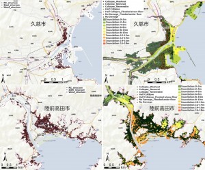
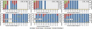
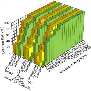
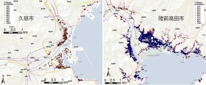
(5) The Development of Building Group Destruction Probability Model Based on the Experience of the Great East Japan Earthquake Tsunami
In order to clarify the tsunami inundation and onshore building damage by Tsunami attack, the inundation height estimated by the tsunami numerical model, building density given by GIS analysis and building damage by field survey were focused on and analyzed. Around the shoreline, almost all buildings were collapsed by tsunami force. With moving to the inland area from the shoreline, the ratio of collapsed buildings decreased and half-collapsed & no-damage ratio were increasing. The inundation depth of central area of Kuji city was below 2m in 79.5% of the inundated area, and building collapse ratio was 31%. At Rikuzentakata city, the inundation depth of 9-11m was dominated in 45.8% of the inundated area and suffered serious damage. From the GIS analysis for building density, the isolated RC & Steel structure buildings were robust like plant, city hall etc.. The high density area’s RC & Steel structure buildings were for apartment building and residence. In case the inundation depth was below 2m, the isolated buildings were lower damage than high density area’s buildings. For wooden building below 2m inundation, the collapsed ratio was decreasing against increasing density. Considering field survey and numerical model output, the building group destruction probability model was developed, and validated at the Iwate coastal areas. By using this probability model, it was able to estimate the building collapse ratio as explanatory variables “type of building structure”, “building density” and “tsunami inundation height”.